
Water utilities across the country are under increasing pressure to do more with less, maintaining aging infrastructure, meeting regulatory mandates, and responding to public safety needs, all while managing limited resources. For utility directors and GIS managers, the key to navigating these challenges lies in building a robust asset management strategy–one that connects field operations with accurate, real-time data and enables proactive decision-making.
In Orem, Utah, that strategy came to life through the integration of GIS and asset management workflows. By combining the spatial intelligence of Esri ArcGIS with the work management automation and reporting capabilities of Novotx Elements XS, Orem’s Water Division has transformed how it inspects, maintains, and prioritizes its water infrastructure. The result: faster response times, improved data quality, and a more resilient utility operation.
“We’re not just tracking work—we’re improving the quality of our GIS data with every inspection,” said Grant Hague, GIS Analyst for Orem. “That’s been a key part of this process. The ability for field crews to update attributes directly in GIS through Elements has made our data more accurate and our operations more efficient.”
Hydrant Flushing: From Four Months to Three Weeks
Orem’s hydrant flushing program once relied on paper maps and manual coordination. The result? Redundant work, missed hydrants, and a four-month timeline to complete citywide flushing. That changed when GIS Analyst Grant Hague and his team implemented a digital workflow using Elements.

“We (the GIS division) proactively created all of the Water’s tasks this year,” said Grant Hague. “So instead of field workers having to create their own task and fill out information, this time they would go into a task that was already made. Once the Task is complete, then it drops off the task list and map so the focus is on the remaining work.”
The impact was immediate. By shifting from paper and spreadsheet-based processes to a GIS-integrated workflow using Elements, Orem’s Water Division dramatically improved the efficiency of its hydrant flushing program.
Previously, it took four months (approximately 16 weeks) to flush all 3,700 hydrants across the city. After implementing the new system, the team flushed 1,900 hydrants—half the system—in just three weeks. At that pace, the full system could now be completed in about six weeks, representing a time savings of over 60%.
“When a hydrant goes out of service, it’s a big deal,” Hague emphasized. “We built the system to notify the right people instantly. That kind of responsiveness wasn’t possible prior to Elements.”
PRV Maintenance: Recurring Tasks, Real-Time Insights
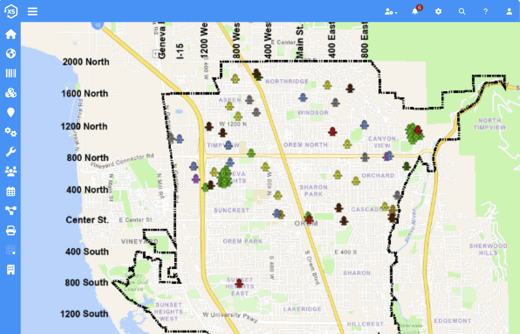
To bring consistency and foresight to PRV maintenance, Orem implemented a GIS-based recurrence system that aligns directly with asset lifecycle management best practices. With limited staff and no centralized tracking, inspections had previously been inconsistent. Grant Hague developed a color-coded scheduling system that automates visual, annual, and five-year rebuild inspections—each tied to the asset’s condition and service interval.

Not wanting to overwhelm the program manager, Hague built an “at-a- glance” map to show what is coming and where to focus. It’s not just about checking a box—it’s about managing the full lifecycle of these assets with the right data at the right time. “Our Program Manager over PRV assets is a mechanical genius, but not a “computer guy,” Hague said. “So, we built a map that shows him exactly what’s due and when. If it’s blue, it’s coming up. If it’s yellow, it’s urgent.”
Each completed inspection automatically generates the next, ensuring nothing falls through the cracks. The system also includes embedded manuals, asset links, and editable GIS attributes—empowering field crews to update data on the spot, rather than waiting to get back to the office.
“We give the people out in the field a lot of power to update GIS attributes through Elements,” said Grant Hague. “That’s been a key part of improving our data quality and making GIS the authoritative source.”
Lead and Copper Compliance: Turning Mandates into Momentum
When the EPA’s Lead and Copper Rule revisions required cities to inventory unknown service line materials, Orem responded with a GIS-driven strategy. Using Esri’s Survey123, the city collected data from residents and paired it with field inspections. Hague then built a workflow in Elements to track and update both sides of the service line.
“We had around 2,400 unknown service lines,” said Grant Hague. “To identify them, we first sent out a survey to customers asking them to report the material on their side of the service line. Then our distribution crews go out to those addresses with a hydro-excavator . They excavate or vacuum out the meter box to expose the pipe on the city side, inspect the material, and update the GIS data directly in Elements. If both the homeowner and city sides are confirmed as non-lead, the line turns blue. If either side is still unknown, it stays red.”
The system also removes completed inspections from the map, helping crews avoid duplication and focus on remaining unknowns. Hague’s team is now using this data to generate next year’s notification list—ensuring compliance and avoiding redundant outreach.
“They’re working hard to accomplish this big project,” Hague added. “And they’re using Elements as a way to track progress and demonstrate compliance to the state.”
Why It Matters
For public works and utility leaders, Orem’s approach demonstrates how GIS and asset management platforms can do more than digitize maintenance workflows—they can transform operations. By aligning fieldwork with real-time data, automating task generation, and integrating compliance tracking, Orem has created a scalable model for modern water utility management.
“GIS is our authoritative source, and Elements gives our crews the tools to act on that data,” said Hague. “Together, they’ve made our infrastructure management more proactive and efficient.”
This story is part of an ongoing series highlighting how the City of Orem is using ArcGIS and Elements XS to transform public works and utilites operations. Stay tuned for more behind-the-scenes looks at the people, processes, and platforms driving smarter infrastructure and better service delivery.