
ASSET MANAGEMENT SOFTWARE FOR PARKS
Where the Grass
Is Greener
Because you’ve got the tools to make it that way.

Smarter Park Maps
With real-time integration to Esri’s ArcGIS platform, you can track playgrounds, trails, trees, and more—all from the map. Visualize your assets, plan smarter, and keep your parks looking their best.

Easy to Use, Built for Crews
Our clean, modern interface is built to be easy for crews and coordinators alike. No steep learning curve—just tools that help you spend less time on screens and more time out in the green.

One System for Every Acre
Manage everything in one place—from mowing schedules and irrigation to tree maintenance and service requests. No jumping between apps, no messy workarounds—just one platform that handles it all.


Built to Fit. Not Pieced Together.
Plays nice because it was built to.
Our platform is a single, unified system built with parks and recreation teams in mind. Every feature is designed by one team with one goal: to simplify your work and help you keep every acre running smoothly.
When systems are pieced together, you get clunky workflows and scattered data. With Novotx, everything connects—from tree maintenance to playground repairs—on one flexible platform built to support your entire department.

One Platform to Rule the Workload
Handle assets, requests, inspections, and more without switching systems (or losing your mind).
From playgrounds to tree inventories, Novotx helps you keep public spaces safe, beautiful, and ready for the community. Schedule work, track maintenance, and make every acre count.
Built for Parks & Rec, Root to Branch
Manage every part of your parks operation—from playgrounds to picnic areas, trails to turf—all in one seamless system. Asset tracking, maintenance, reservations, inspections, and more, designed to keep your parks thriving and your team running smoothly.
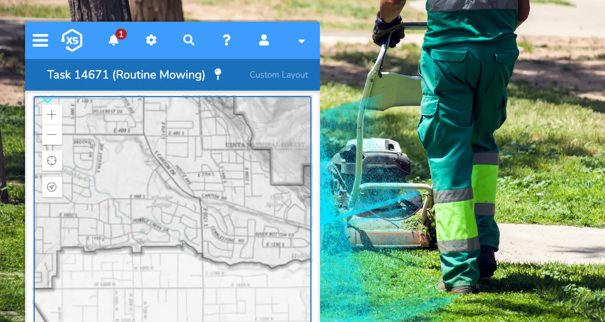
Maps Anywhere

Elements XS offers seamless integration with Esri’s ArcGIS platform, letting you use your native web maps and apps right inside the system. Work from any device, online or offline, with iOS and Android apps that keep your data in sync when you’re back connected.
No More Syncing
Your GIS is the single source of truth for all spatial data. Elements XS eliminates the need to copy or synchronize information, keeping your asset records accurate and up-to-date—so you can focus on managing, not merging.
Data That Works

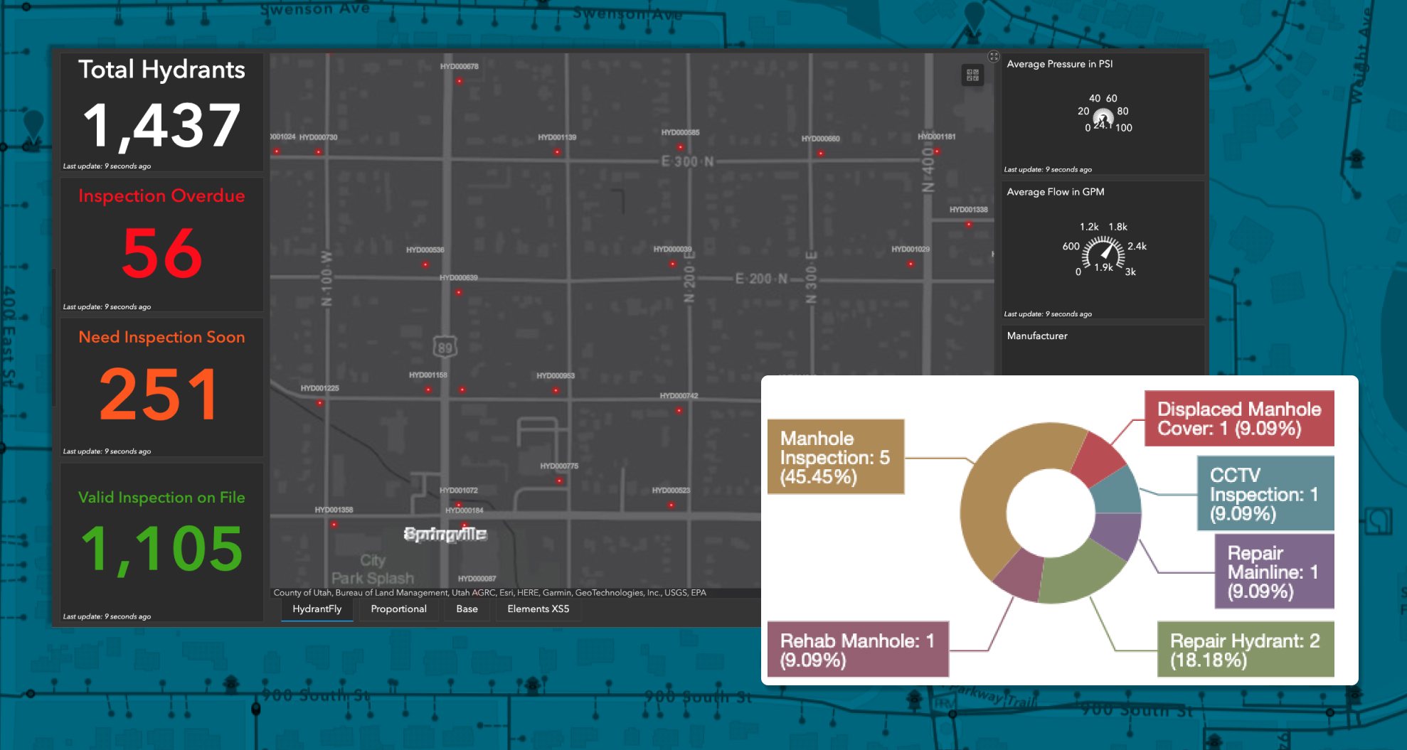
Use live, public-facing maps to share real-time asset management, billing, and project updates. Leverage powerful reports, dashboards, and map-based analytics, powered by ArcGIS, to prioritize maintenance, assess risk, and make smarter decisions.
Asset Management
From playgrounds to pavilions, track every asset and task in one easy-to-use system. Log inspections, manage repairs, and respond to requests fast. Use condition scores, maintenance schedules, and smart analytics to prioritize what needs attention before it turns into a bigger issue.

Maintenance Made Simple
Automate mowing, irrigation checks, and recurring facility maintenance with flexible schedules that keep your parks in top shape. Track every request and work order—from trail repairs to tree trimming—complete with labor, materials, and equipment costs. Keep your community in the loop with real-time updates and measure performance against your standards.
Scheduling That Just Works
Let your community reserve fields, pavilions, or event spaces online through your custom-branded portal. Cut down on back-and-forth, speed up approvals, and make it easier for everyone to enjoy your parks.

Create Your Perfect Setup
Customize your workflows, automate the busywork, and get the job done, whether you’re in the office or out in the field.

Make It Yours
Shape the platform around how your parks department actually works, from playground inspections to pavilion requests. Create custom fields, forms, lists, and workflows that make sense for your staff and your spaces.

Set It and Forget It
From recurring mow schedules to facility maintenance reminders, set up automations that keep everything moving without manual follow-up. Route work, send notifications, and handle the details—automatically.

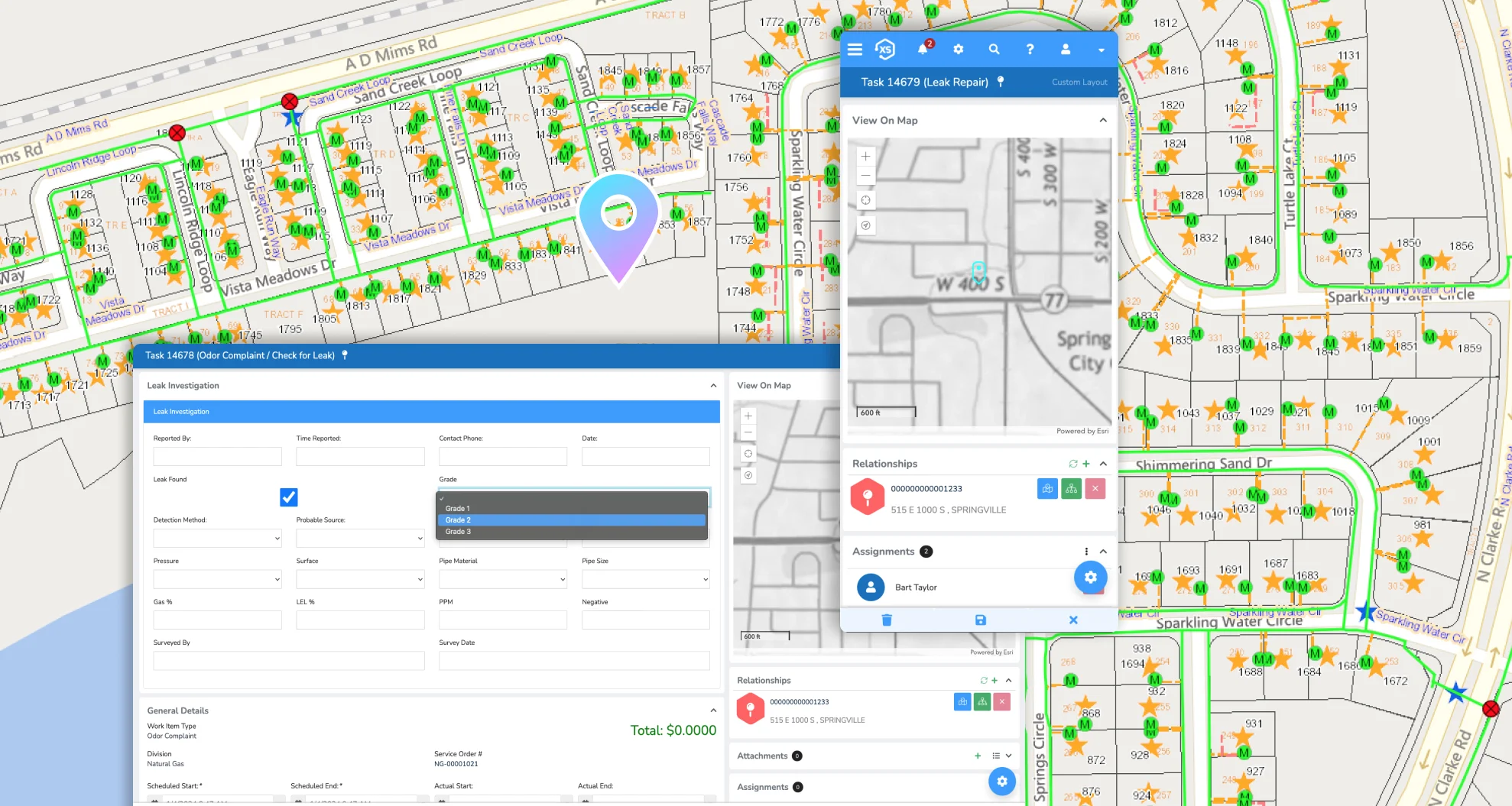
Put it on the Map
Use Esri ArcGIS maps to manage your parks visually. Select multiple assets—like trees, restrooms, or ball fields—and take action in a few clicks. Assign tasks, log costs, and update records right from the map.

Ping the Right People
Trigger updates for staff, contractors, and community members automatically. Whether it’s a completed repair or an upcoming reservation, everyone gets the info they need, when they need it.

Custom without the Chaos
Build as many forms, fields, lists, and automations as your team needs. Whether you’re managing permits, events, or trails, the platform adjusts to your workflow, not the other way around.

Anytime, Anywhere
Whether you’re out checking irrigation lines or logging a repair on a slide, you can get it done on any device, with or without a connection. Your data catches up when you do.
Mitigate Risk
Maintain a clear digital history of your parks, trails, and facilities as they change over time. Track conditions, monitor sensitive areas, and use smart scoring tools to prioritize maintenance—helping you protect and preserve every green space.

Parks Don’t Manage Themselves.
But with our tools, it sure feels like they do.