
ENTERPRISE PERMITTING SOFTWARE FOR UTILITIES AND LOCAL GOVERNMENT
Smarter Permits,
Happier Communities
Seamlessly manage applications, inspections, and approvals—all connected with real-time GIS integration for transparency and efficiency.

Building Permits
Manage everything from new construction to commercial and residential projects. Track permit applications, fees, inspections, approvals, and more—all in one place.

Right of Way Permits
Handle permits for utilities, obstructions, events, and more. Keep tabs on applicants, contractors, application details, inspections, fees, and all associated information.

Any Application
Streamline land use, conditional use, special events, sewer taps, water rights, and any other permits your utility or local government requires.


This is not a pre-boxed permitting app, it’s is a flexible enterprise platform used across many departments.

Commercial

Residential

New Construction

Remodels

Alcohol

Fences

Traffic

Signs
Smarter Permitting Starts
With a Unified System.
Connect permitting, licensing, inspections, and asset management in a single platform that works across departments. Elements XS is built to handle all the moving parts—applications, fees, reviews, approvals, and beyond—with GIS-driven workflows, mobile access, and intuitive tools for both office and field staff.

Asset Management
Permit records can easily be connected to assets such as infrastructure, parcels, and utilities—track inspections, associated costs, and all work performed in context—no extra software needed.
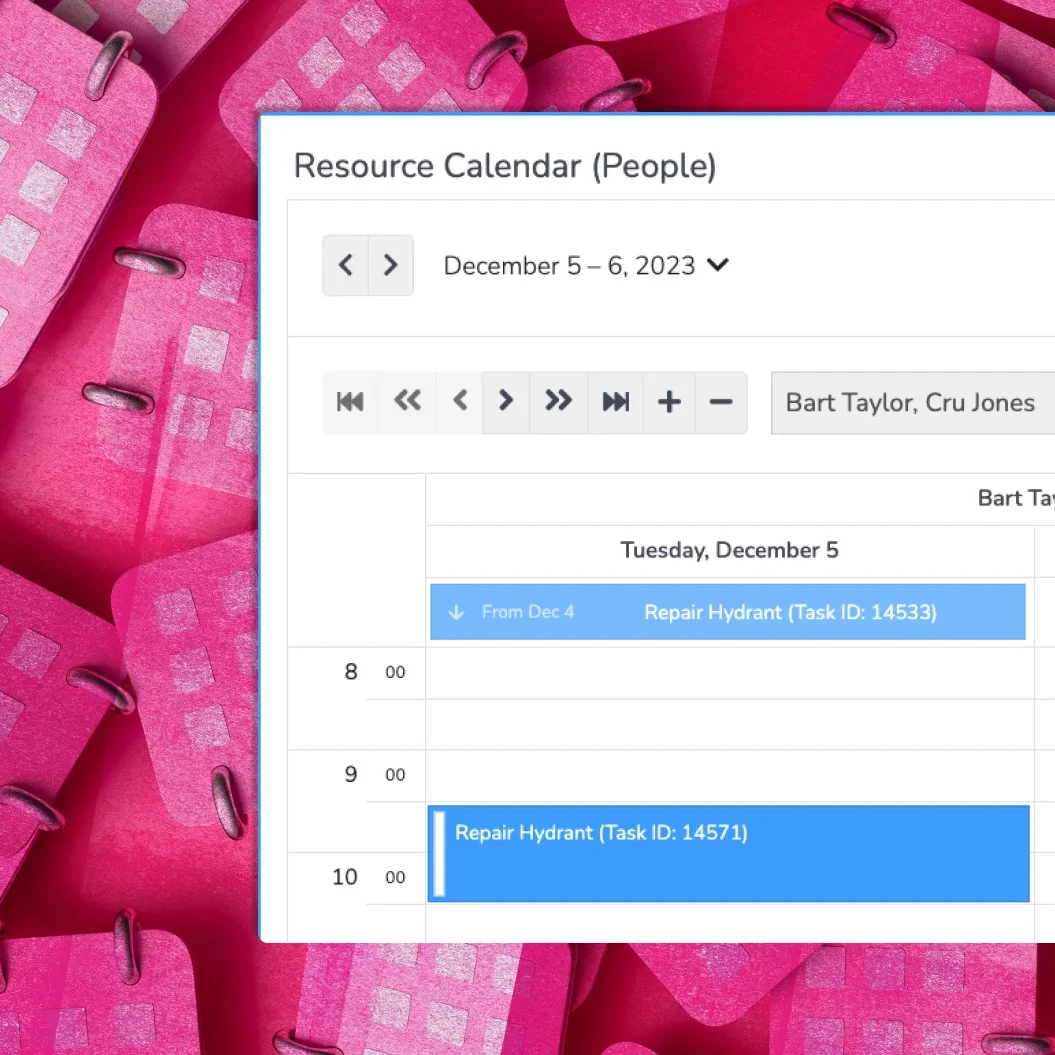
Calendars & Scheduling
Built-in scheduling tools make it easy to coordinate inspections, balance workloads, and avoid delays. View tasks by inspector, location, or permit type so you can plan ahead and stay efficient.

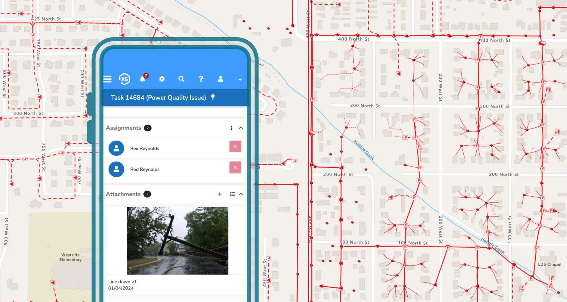
Configurable Inspections
Tailor inspection forms to fit each permit type. Monitor status, capture results, and flag follow-ups—all connected to the related application and assets.
Bring Your Permitting Process
to Life with Maps
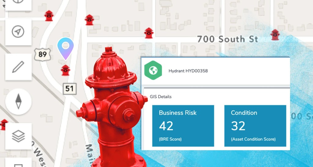
Visualize every application, inspection, and approval.
Use your own ArcGIS maps to see where permits are active, inspections are due, and approvals are pending—right down to the parcel.
Real-Time ArcGIS Integration
Your GIS is always in sync.
Direct, real-time integration with Esri’s ArcGIS means no syncing, no duplication—just live data powering both your internal workflows and public-facing maps.

Share What Matters
Show progress and build trust.
Easily publish maps that display application statuses, inspection results, project boundaries, and more—right from your native ArcGIS system.
Powerful, Flexible,
and Built for the Real World
Whether managing building permits, Right of Way, business licenses, or conditional use applications, Elements XS supports your entire process from intake to approval. It reduces redundant systems, simplifies workflows, and gives every stakeholder real-time access to the same trusted data.
One Connected Platform
Manage everything from one place—with no duplicate data entry.
Handle permit applications, inspections, approvals, payments, and communications all in one system. Seamlessly integrated with your GIS, asset management, billing, and more—eliminating duplicate data entry and disconnected apps. Everyone stays aligned with accurate, up-to-date information.


Tailored Workflows
Custom workflows for any type of permit or license—no custom code required.
Create custom forms, route applications by type or location, configure review processes, and automate notifications—all with easy, point-and-click tools. No coding required. Adapt processes for planning, utilities, public works, or special events, and evolve as your needs grow.
Smarter with GIS
Use location intelligence to work faster, smarter, and more transparently.
Our direct, real-time integration with ArcGIS puts your own maps at the center of the permitting process. Automatically connect applications to assets, parcels, or zones, and display application statuses on public-facing maps for added transparency. No sync jobs, no duplicated data—just one authoritative source of truth.

Built for Everyone
Built for applicants, reviewers, inspectors, and everyone in between.
Applicants enjoy a simple online experience—submitting forms, uploading documents, paying fees, and tracking progress. Staff benefit from centralized dashboards and automated alerts to keep workflows moving. Field inspectors can work on any device, online or offline, updating records on the go.

Need a Head Start?
While Connect is built for flexibility, we also offer ready-to-use permitting workflows to help you hit the ground running. Our team can tailor them to fit your exact needs.
Create a Permitting Experience
That Works for Everyone
Flexible. Powerful. Built for how you work.
Design the permitting process that fits your agency—not the other way around. From custom forms to mobile workflows, everything is configurable.

Automate the Process
Trigger follow-up steps, assign reviews, notify stakeholders, and route approvals automatically based on your business rules.

Take Action with Maps
Use your ArcGIS maps to select multiple parcels or assets and apply updates in bulk. Add costs, inspections, and more—all in a single click.

Keep Everyone Updated
Set up automated email, text, or in-app notifications to keep applicants, inspectors, and staff in the loop every step of the way.

Customize Everything
Build as many custom forms, record layouts, and workflows as you need. Configure the interface to simplify tasks and eliminate clutter.

Work Anywhere
Submit applications, complete inspections, and update records from any device—even without internet. Everything syncs when you’re back online.

Track the Full Lifecycle
From submission to approval, inspections, fees, and follow-up tasks—track every step in one place.

Simplify Your Permitting Process
See how Elements XS can transform the way your team manages permits and licenses—streamlining workflows, improving transparency, and empowering every user.